Who Owns the Future? -
Find out how data mining is widening the gap between the upper and middle classes.
|
Wednesday, 22 April 2026
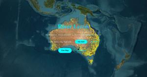
quote [ National telemetry and flow representation for Australian rivers. Access live map data, flood warnings, and catchment monitoring. ]
Screw beating the bush, set that MOFO on fire; plant a seed in the ashes and water and treat it well & with kindness.
|
Comments
|
Paracetamol said @ 6:41am GMT on 23rd Apr
[Score:1 Insightful]
that's pretty impressive. But if I get this right, it's a flood info dashboard and a traditional name register in one?
|
|
R1Xhard said[1] @ 1:54pm GMT on 23rd Apr
It's the River section of a project working on Eco Levels.
I had a section that displayed tips and such about areas, but felt very Colonial. Attended a Science Symposium about river levels and pollutant wash-out that affects Great Barrier Reef, made me think I wanted to integrate more First Nation data on in data presentation. Reminded of the nepo bureaucratic -ism that language and translation data access is. Researched this area before and after not addressing for a year, having a convo with a professor in the field and being told that's a major undertaking {yea or just some thought maybe put in}. Finding that AUS Post has a page on the formal way to write this data. They don't have a simple tool to check your correctness, actually refer to a "map" that was collated in 1993-4. After contemplation for an hour or 2 and looking what list had been collated around. Well LGAs (Local Government Areas) cover the shire/county level,their official public document releases have a Welcome to Country stating that regions Traditional Owners. Collate the 500+ into a table and merge. So yea, "...a flood info dashboard and a traditional name register in one..." -Paracetamol Note from 5pm Wednesday to 5am Thursday after that convo with Professor and AUSPost, got this bashed together; already had the map and river data just needed to collate the data, merge and present. |
|
Paracetamol said @ 2:01pm GMT on 23rd Apr
[Score:1 Informative]
also, it's the first time ever someone mentions me in the comments, I didn't even know there is a seprate notification for that.
|
|
Paracetamol said @ 2:00pm GMT on 23rd Apr
Aah, yes, that sounds like a sensible approach. Indeed I realized too that there's a lot of public data floating around (in my case, geolocation points correlating to ZIP codes) that are way easier to handle than some obscure API calls by just keeping a statc table around in the backend.
|
|
R1Xhard said @ 2:08am GMT on 24th Apr
Bi-Line inspiration from 0:14-0:24.
Thinking of adding the bi-line: Starts at the Headwaters and flows From the river to the sea. It's just illegal to use "From the river to the sea." in QLD. "Starts at the Headwaters and flows From the river to the sea." Just refers to the flow of water being measured by the gauges. |
|
R1Xhard said @ 10:03pm GMT on 22nd Apr
Well that's an opinion
|
Post a comment
[note: if you are replying to a specific comment,
then click the reply link on that comment instead]You must be logged in to comment on posts.