Anxious -
Using the Brain to Understand and Treat Fear and Anxiety
|
Wednesday, 22 April 2026
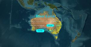
quote [ National telemetry and flow representation for Australian rivers. Access live map data, flood warnings, and catchment monitoring. ]
Screw beating the bush, set that MOFO on fire; plant a seed in the ashes and water and treat it well & with kindness.
|
R1Xhard said @ 1:54pm GMT on 23rd April
It's the River section of a project working on Eco Levels.
I had a section that displayed tips and such about areas, but felt very Colonial.
Attended a Science Symposium about river levels and pollutant wash-out that affects Great Barrier Reef, made me think I wanted to integrate more First Nation data on in data presentation.
Reminded of the nepo bureaucratic -ism that language and translation data access is.
Researched this area before and after not addressing for a year, having a convo with a professor in the field and being told that's a major undertaking {yea or just some thought maybe put in}.
Finding that AUS Post has a page on the formal way to write this data. They don't have a simple tool to check your correctness, actually refer to a "map" that was collated in 1993-4.
After contemplation for an hour or 2 and looking what list had been collated around.
Well LGAs (Local Government Areas) cover the shire/county level,their official public document releases have a Welcome to Country stating that regions Traditional Owners.
Collate the 500+ into a table and merge.
So yea, "...a flood info dashboard and a traditional name register in one..." -Paracetamol
R1Xhard said @ 1:56pm GMT on 23rd April
It's the River section of a project working on Eco Levels.
I had a section that displayed tips and such about areas, but felt very Colonial.
Attended a Science Symposium about river levels and pollutant wash-out that affects Great Barrier Reef, made me think I wanted to integrate more First Nation data on in data presentation.
Reminded of the nepo bureaucratic -ism that language and translation data access is.
Researched this area before and after not addressing for a year, having a convo with a professor in the field and being told that's a major undertaking {yea or just some thought maybe put in}.
Finding that AUS Post has a page on the formal way to write this data. They don't have a simple tool to check your correctness, actually refer to a "map" that was collated in 1993-4.
After contemplation for an hour or 2 and looking what list had been collated around.
Well LGAs (Local Government Areas) cover the shire/county level,their official public document releases have a Welcome to Country stating that regions Traditional Owners.
Collate the 500+ into a table and merge.
So yea, "...a flood info dashboard and a traditional name register in one..." -Paracetamol
Note from 5pm Wednesday to 5am Thursday after that convo with Professor and AUSPost, got this bashed together; already had the map and river data just needed to collate the data, merge and present.
<-- Entry / Current Comment
R1Xhard said @ 1:54pm GMT on 23rd April
It's the River section of a project working on Eco Levels.
I had a section that displayed tips and such about areas, but felt very Colonial.
Attended a Science Symposium about river levels and pollutant wash-out that affects Great Barrier Reef, made me think I wanted to integrate more First Nation data on in data presentation.
Reminded of the nepo bureaucratic -ism that language and translation data access is.
Researched this area before and after not addressing for a year, having a convo with a professor in the field and being told that's a major undertaking {yea or just some thought maybe put in}.
Finding that AUS Post has a page on the formal way to write this data. They don't have a simple tool to check your correctness, actually refer to a "map" that was collated in 1993-4.
After contemplation for an hour or 2 and looking what list had been collated around.
Well LGAs (Local Government Areas) cover the shire/county level,their official public document releases have a Welcome to Country stating that regions Traditional Owners.
Collate the 500+ into a table and merge.
So yea, "...a flood info dashboard and a traditional name register in one..." -Paracetamol
Note from 5pm Wednesday to 5am Thursday after that convo with Professor and AUSPost, got this bashed together; already had the map and river data just needed to collate the data, merge and present.